Monday, March 7, 2016

Indian Villages, Reservations, and Removal

We're all familiar with the basic story of how this country got its land: it was taken from the Native Americans by a series of treaties, many signed under duress, that "purchased" the land well below its actual value. But some of the details of these events are not well known, especially locally. When and how did the ground beneath our feet in Metro Detroit change hands from Native American to European American ownership?

This post isn't about streets and borders, but the story of the First Nations' dispossession of this land is a vital part of its history.
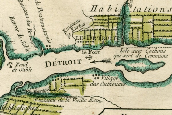

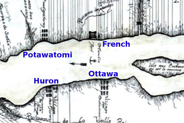
Potawatomi, French, Wyandot (Huron), and Ottawa settlements, circa 1750.
Image courtesy Detroit Historical Society.
(Source.)

When the French began to explore the Great Lakes at the beginning of the 17th century, southeast Michigan was home to the Fox and Kickapoo nations. Europeans brought with them the disruptive fur trade, instigating the Beaver Wars (1638-1701). The well-armed Iroquois, having exhausted the supply of beaver in upstate New York, conquered the territory to their west, ultimately forcing the Fox and Kickapoo out of Michigan.

For decades, southern Michigan was essentially a no man's land. When LaSalle crossed the lower peninsula on foot in 1680, he found the region to be virtually desolate.
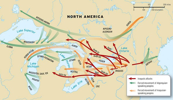

Forced migration by Iroquois Nation during the Beaver Wars.
Image courtesy Oxford University Press.
(Source.)


The French Era (1701-1760)


By the time Antoine de la Mothe Cadillac was about to establish Fort Pontchartrain at Detroit in 1701, the Iroquois were losing control of their conquered territory. They were among the forty tribes negotiating the Great Peace of Montreal when Cadillac landed on July 24, 1701. Although Detroit was founded for military and economic reasons, it also had a more Utopian goal: to "bring the tribes together," as Cadillac wrote. He optimistically urged every tribe he could to join the settlement, but the results were not always what was intended.
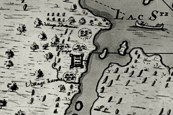

Map of Detroit in 1702, reportedly drawn by Cadillac himself.
Image courtesy Burton Historical Collection, Detroit Public Library.
(Source.)

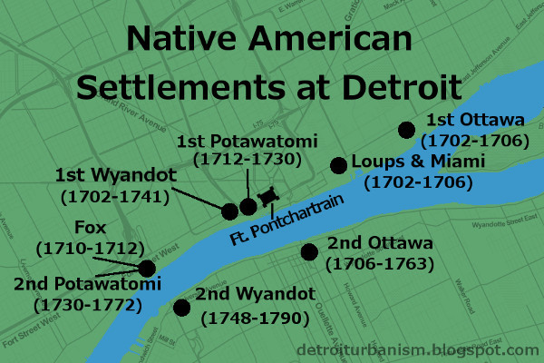
In the year after Detroit's founding, bands of Wyandot (Huron), Ottawa, and "Loup" (probably Oppenago) settled close to the French fort. Bands of Miami arrived and lived in a consolidated village with the Loups in 1702 or 1703. In 1706, a fight between the Ottawa and Miami caused the Ottawa to relocate to the opposite side of the river by 1708. The Miami moved to the Maumee River in Ohio around the same time. Chippewa and Mississauga bands arrived in 1703, but built their first joint village at a safe distance from Detroit, at the head of Lake St. Clair.

Worse violence erupted after Cadillac invited Fox, Kickapoo, and Mascouten allies from Wisconsin to Detroit. They arrived around 1710, settling near where the Ambassador Bridge meets U.S. soil now. After skirmishes between their allies and the other Detroit tribes, a large group of Fox warriors built a fortified camp just north of Fort Pontchartrain in the spring of 1712. Most of the tribes friendly to the French were still away on their winter hunting trips. The Fox finally attacked the French fort on May 13, 1712, but the Huron and Ottawa hunters soon returned, chasing the Fox back into their encampment. After a two-week siege, the Fox fled. They were pursued to the shores Lake St. Clair where they were cornered and slaughtered. Some escaped, returning to Wisconsin. The Fox, Kickapoo and Mascouten never again settled near Detroit.
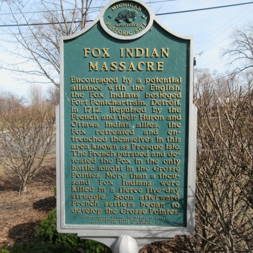

Fox Indian Massacre historical marker in Grosse Pointe Park.
Photograph by the author.

The Potawatomi came to Detroit around 1712-1714, temporarily settling in between the Wyandot (Huron) and French forts. As safety and stability returned to Detroit, the Potawatomi gradually moved downstream, establishing their permanent settlement on the site of the old Fox village (the Ambassador Bridge site) at some point before 1732. Chaussegros de Léry's 1749 map of the Detroit River also shows some Potawatomi dwellings at the mouth of the Ecorse River.

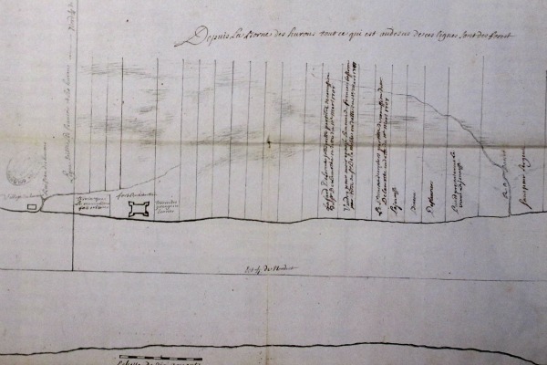
Animosity between the Wyandot and the Ottawa in 1738 caused the first tribe to abandon their fortified village and move to Sandusky Bay. The group later split in two, with one faction forming a village on the Canadian shore of the Detroit River just opposite Isle aux Bois Blancs (Boblo Island) in 1742. The Sandusky Wyandots attacked Detroit and burned the Bois Blancs village in 1747. The displaced Wyandots settled closer to Detroit, across the river from the Potawatomi. This arrangement--the Potawatomi and French on the north shore, and the Wyandot and Ottawa on the south--remained stable for fifteen years.


Life in the Villages


The First Nations at Detroit lived on the strait throughout the warmer months of the year, where they raised various crops and traded with the French. Each winter, most or all of a village would camp and hunt in the forests of Michigan and Ohio.

The French population of Detroit grew to 270 within its first decade, but its Native American population was more than four times that. By 1736, there were 580 Native American warriors at Detroit--implying a total population of approximately 2,000. By contrast, Detroit's total white population was a mere 800 as late as 1765.

The Potawatomi originally built single-family huts while the Wyandot, an Iroquoin people, constructed longhouses. By the 1730s, observes researcher Brian Leigh Dunnigan, "it would appear that the Ottawa and Potawatomi had accepted the usefulness of the multi-family longhouse, at least for their permanent villages at Detroit, an example of cross-cultural exchange stimulated by the close proximity in which the three Native American groups were living."
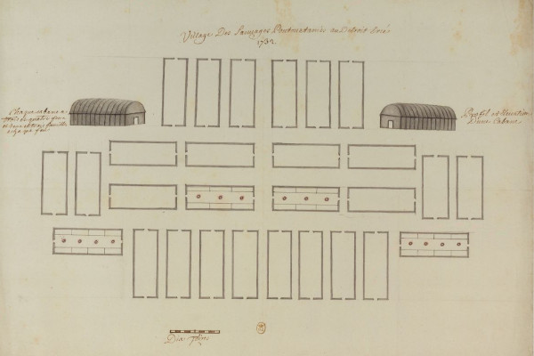

The second Potawatomi village, drawn by Commandant Henri-Louis Deschamps de Boishébert, 1732. The U.S. end of the Ambassador Bridge occupies this space now. (Source.)

The following description of Native American settlements at Detroit is worth quoting at length. When it was written, in 1718, the Wyandot and Potawatomi settlements were just west of Fort Pontchartrain.
The village of the Poutouatamies adjoins the fort; they lodge partly under the Apàquois [huts], which are made of mat grass. The women do all the work. The men belonging to that Nation are well clothed, like our domiciliated Indians at Montreal; their entire occupation is hunting and dress; they make use of a great deal of vermillion, and in winter wear buffalo robes richly painted, and in summer, either blue or red cloth.

They play a good deal at La Crosse in summer, twenty or more on each side... This is fine recreation and worth seeing. They often play village against village; the Poux
[Potawatomi] against the Outaouacs [Ottawa] or the Hurons [Wyandot], and lay heavy stakes. Sometimes Frenchmen join in the game with them.

The women cultivate Indian corn, beans, peas, squashes and melons, which come up very fine.... When they go hunting, which is every fall, they carry their Apàquois with them to hut under at night. Every body follows, men, women and children, and winter in the forest and return in the spring.

The Hurons are also near; perhaps the eighth of a league from the French fort. This is the most industrious nation that can be seen. They scarcely ever dance, and are always at work; raise a very large amount of Indian corn, peas, beans; some grow wheat. They construct their huts entirely of bark, very strong and solid; very lofty and very long, and arched like arbors. Their fort is strongly encircled with pickets and bastions, well redoubled, and has strong gates.... The men are always hunting, summer and winter, and the women work. When they go hunting in the fall, a goodly number of them remain to guard the fort....

The soil is very fertile; Indian corn grows to the height of ten or twelve feet; their fields are very clean, and very extensive; not the smallest weed is to be seen in them.
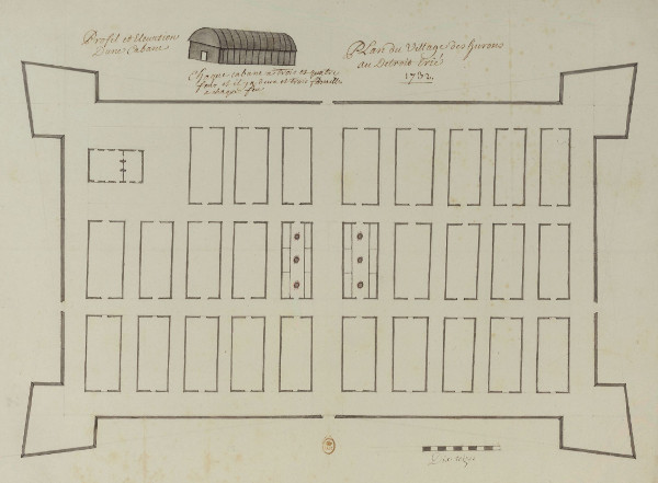
The first Wyandot village, drawn by Commandant Henri-Louis Deschamps de Boishébert, 1732. The Joe Louis Arena parking garage stands here today.
Image courtesy National Library of France.
(Source.)
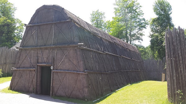

A reconstruction of a Wyandot longhouse in Midland, Ontario.
Image by Flickr user andres musta.
(Source.)
The Outaouaes are on the opposite side of the river, over against the French fort; they, likewise, have a picket fort. Their cabins resemble somewhat those of the Hurons. They do not make use of Apàquois except when out hunting; their cabins in this fort are all of bark, but not so clean nor so well made as those of the Hurons. They are well dressed, and very laborious, both in their agriculture and hunting. Their dances, juggleries and games of ball (la crosse) and of the Bowl are the same as those of the Poux...

The Hurons number one hundred men; the Poux, 180; the Outaouaes, about one hundred men and a number of women.

Twelve leagues...up the river, you will find the Misisagué
[Mississauga, who lived with the Chippewa] Indians, who occupy a beautiful island where they raise their crops. They are about 60 or 80 men. Their language resembles that of the Outaouae; there is very little difference between them. Their customs are the same, and they are very industrious.

All these Nations construct a great many bark canoes, which is a great assistance to them; they occupy themselves in this sort of work; the women sew the canoes with roots; the men finish and make the [ribs] of these canoes, smoothen and floor
(varanguent) them, and the women gum them. It costs some labor to build a canoe; it requires considerable [pains] and preparation, which are curious to behold.


Pontiac's War


The British takeover of Detroit in 1760 was followed by Pontiac's War three years later. Members of all the Detroit tribes supported Pontiac's siege of the fort, which began May 9, 1763. The Ottawas (Pontiac's tribe) encamped east of the British fort at that time. Although Native Americans captured most of the British forts west of the Appalachians, Detroit was never taken, and the siege ended with a truce on October 31.

Native Americans began to distance themselves from the British fort afterwards. The Ottawa were the first to leave, relocating to the Maumee River in Ohio soon after the standoff ended. Pontiac began selling Ottawa property on the Detroit River as early as 1765, when a portion of the land was sold to Alexis Masonville in September of that year.

In the following decade, the Wyandot began to move to new villages downriver from Detroit. Maguaga (also spelled Maguagua and Monguagon) was located in what is now the City of Wyandotte. Brownstown, on Brownstown Creek, was named for village chief Adam Brown, a Caucasian who as a child was kidnapped and raised as a Wyandot. Brownstown was also sometimes known as Sindathon's Village.
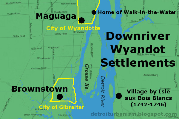

The Potawatomi also began to leave the Detroit River in the 1770s. They sold their land piecemeal and established new villages farther inland, along the Huron and Rouge Rivers.

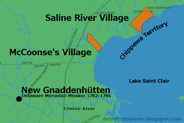
One short-lived settlement in Macomb County deserves mentioning. Christian Delaware Indians seeking refuge from American colonists after a brutal massacre in Ohio found safe haven on the Clinton River thanks to Detroit's British commandant and Chippewa guides. They were led by a European-born Moravian preacher, David Zeisberger, and landed on July 22, 1782. They named the new settlement New Gnaddenhütten (Tents of Grace). After barely four years at this location, they departed for a new site in Ontario on April 20, 1786.


Timeline Leading Up to Removal


  • 1763—Britain attempts to improve Indian relations, prohibiting colonial settlement west of the Appalachians.
  • 1775-1783—Throughout the Revolutionary War, most Native Americans side with the British.
  • 1782—In peace negotiations with the United States of America, Great Britain proposes an independent "Indian state" between the Ohio River and the Great Lakes. The U.S. will not even consider the idea.
  • 1783—The Treaty of Paris ends the war and cedes the Indian territory to the U.S. No Native Americans were party to the agreement, and they still see the land as theirs.
  • 1786—Tribes of this territory form the Western Confederacy and move their Council Fire to Brownstown. They issue a speech to the Continental Congress nullifying land purchases made without their consent and urging the U.S. not to enter their territory.
  • 1789—Council Fire moves to Kekionga, present-day Fort Wayne, Indiana.
  • 1790—U.S. and Western Confederacy fail to prevent violence between white settlers and native warriors. The U.S. sends 1,450 troops under General Josiah Harmar, who is defeated in every battle with Native Americans and retreats.
  • 1791—Major General Arthur St. Clair marches into Indian territory in a disastrous campaign. Of his 920 soldiers, 632 (69%) were killed and 264 were wounded (more than three times the death toll of Custer's defeat at Little Big Horn, where 268 of 647 soldiers were killed). The Western Confederacy loses just twenty-one warriors.
  • 1792—George Washington appoints "Mad Anthony" Wayne commander of the United States Army of the Northwest. Blaming past failures on untrained militiamen and inadequate supplies, congress funds a new, professional army under Wayne's direction. He begins building forts in Indian territory.
  • August 20, 1794—Wayne confronts the forces of the Western Confederacy and achieves a decisive victory at the Battle of Fallen Timbers.
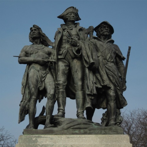

The Battle of Fallen Timbers Monument (1929) by Bruce Saville, depicting
an Indian warrior, General "Mad Anthony" Wayne, and a frontiersman.
Photograph by the author.


Indian Removal (1795-1842)


There is a strange dichotomy in U.S.-Native American policy: Tribes are recognized as sovereign nations whose land titles are undisputed; and yet the U.S. government throughout most of history was resolved to extinguish that title by any means necessary.
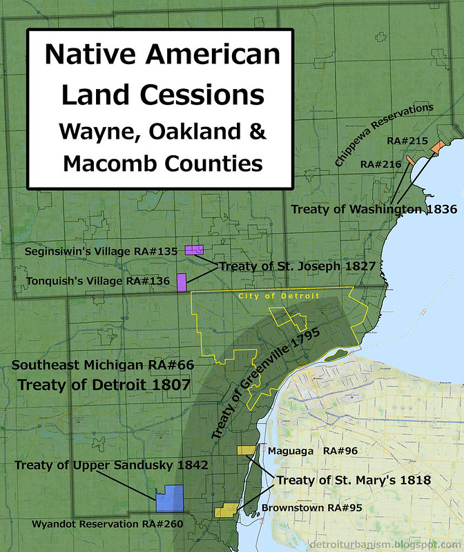

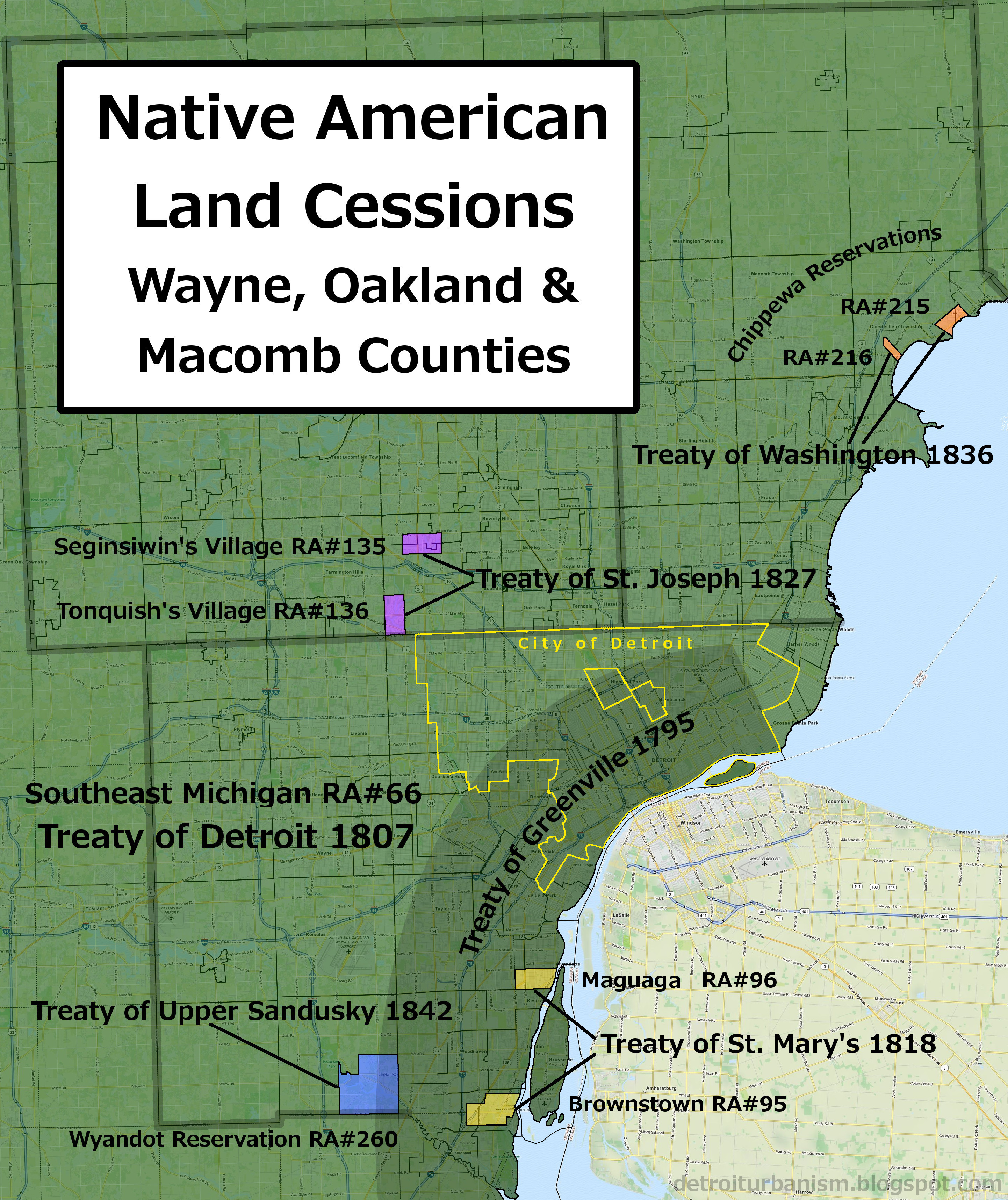
CLICK HERE TO VIEW A LARGER VERSION OF THIS MAP.

What follows are the six treaties and one act of Congress that either granted or extinguished Indian land titles in Wayne, Oakland, and Macomb Counties. Much of this data comes from the research of Charles C. Royce, whose meticulous catalog of land cessions and reservations was published in 1897 for the Eighteenth Annual Report of the Bureau of American Ethnology to the Secretary of the Smithsonian Institution. Royce assigned each tract with a number, now referred to as Royce Area (RA) numbers.


Treaty of Greenville (1795)
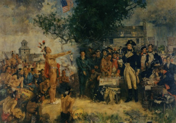


Signing of the Treaty of Greene Ville, by Howard Chandler Christy.
Miami Chief Little Turtle presents a wampum belt to General Wayne.
Image courtesy OhioHistory.org.
(Source.)

In addition to ending the war between the Western Confederacy and the U.S., this treaty ceded to the U.S. most of present-day Ohio and several other areas, including all land within six miles of the Detroit River. The treaty was signed August 3, 1795.

In exchange for ceded land, the U.S. gifted the represented tribes goods valued at $20,000, in addition to gifts valued at $9,500 (divided among twelve tribes) to be delivered every year after that. The tribes also conceded that they were under the "protection" of the U.S. government and no other power.


Treaty of Detroit (1807)


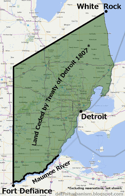
William Hull, Governor of the Michigan Territory, negotiated this treaty with the Ottawa, Potawatomi, Chippewa, and Wyandot Indians of southeast Michigan. The boundary of the ceded lands began at Fort Defiance, Ohio, went due north until reaching a latitude parallel with the mouth of the St. Clair River; from there, northeast to White Rock in Lake Huron, a well-known landmark among Native Americans; from White Rock, south along the coastline to the Maumee River; then up the river back to Fort Defiance. Since this area includes the Treaty of Greenville cession, both are designated RA#66 in the Royce Area numbering system.
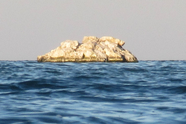

The White Rock of Lake Huron.
Photograph by the author.

Excluded from this cession were several reservations, including two Potawatomi reservations in Oakland County and two Chippewa reservations in Macomb County. The treaty permitted the Indians to hunt on the ceded land as long as it remained federal property. The U.S. paid "ten thousand dollars, in money, goods, implements of husbandry, or domestic animals," divided among the four nations, and promised an annuity of $2,400 to all tribes after that. The treaty was signed November 17, 1807. Click here to view the signature page of this treaty.


"An Act for the Relief of Certain Alabama and Wyandot Indians" (1809)


When the Wyandots of Maguaga and Brownstown complained that their settlements were omitted from the reservations of the 1807 Treaty of Detroit, the U.S. Congress passed a law on February 28, 1809 granting them two reservations. They were to coincide with the villages of Maguaga and Brownstown, not to exceed five thousand acres combined. The grant was to expire after fifty years.
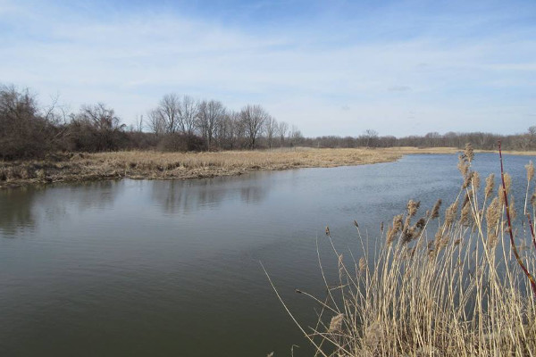

The former site of the Wyandot village of Brownstown, once the site of the Western Confederacy's Council Fire. Today the land is a federal wildlife preserve.
Photograph by the author.

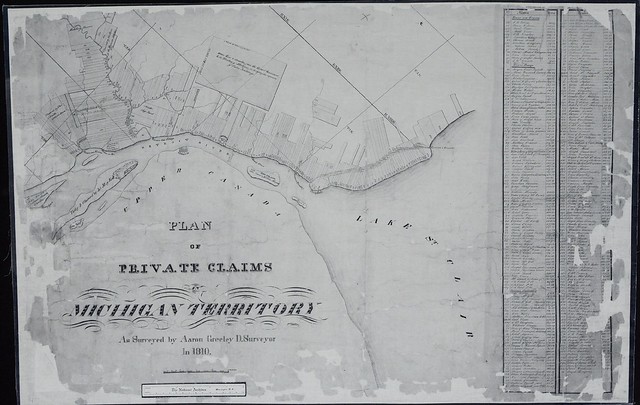
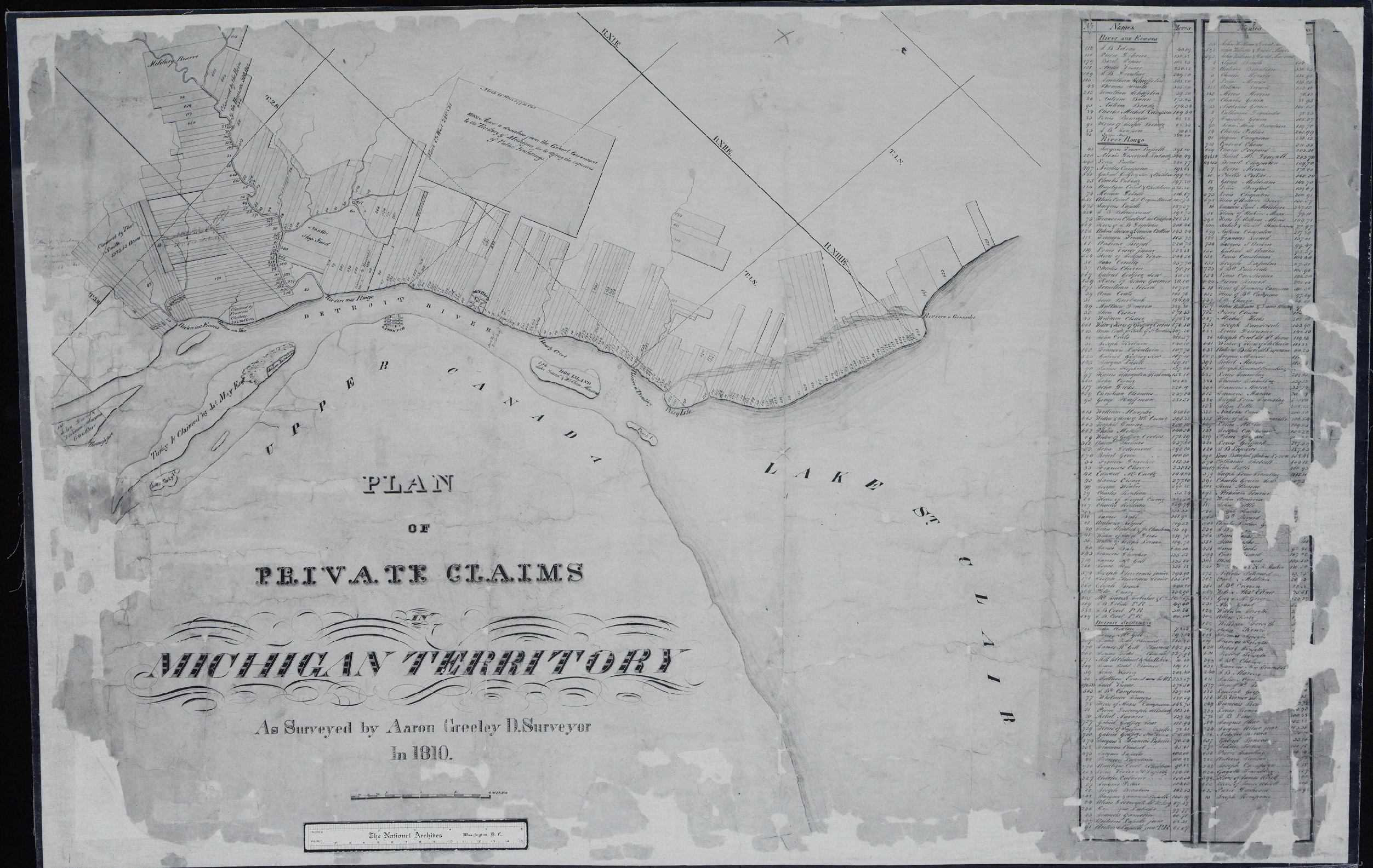
It's interesting to note that Brownstown's village chief Adam Brown applied for title to two tracts of land land encompassing his village as private claims in 1808. They were granted to him the following year as Private Claims No. 354 & 355. Brown's adopted son, William Walker, applied for title to two adjacent claims and likewise received them (PC No. 54 in 1807, and PC No. 345 in 1809).
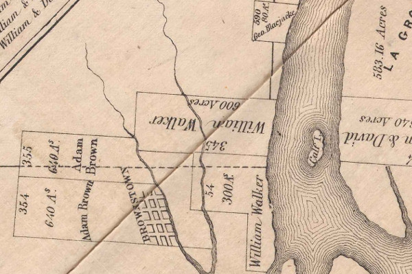

Detail from Plan of Private Claims in Michigan Terr. as Surveyed by Aaron Greeley.
Image courtesy Detroit Historical Society.
(Source.)

Included in the image above is the farm of George Bluejacket, PC No. 590, granted in 1808. George Blue Jacket was the son of the Shawnee warrior Chief Blue Jacket, who fought at the Battle of Fallen Timbers and was a signatory of the Treaty of Greenville. The elder Blue Jacket also lived in this area until his death in 1808, but it's not known if he occupied the same farm.

By this time, the Wyandot could no longer support themselves by hunting. They engaged in European farming practices, kept livestock, and built log cabins.


The War of 1812


The dream of Indian independence was revived under the leadership of Shawnee warrior Tecumseh, and the War of 1812 presented an opportunity to ally with Britain against the United States. Tecumseh's men fought near Brownstown and Maguaga before marching on Fort Detroit. The presence of his 600 warriors contributed to its surrender in August 1812. But just one year later, Indian and British soldiers had abandoned Detroit and were being pursued by U.S. forces. Tecumseh was killed when his men stood their ground at the Battle of the Thames on October 5, 1813.

The events at the end of the war echoed the end of the American Revolution: the British had abandoned their Native American allies; in peace negotiations, Britain proposed an Indian state, which the U.S. rejected; and the final peace treaty excluded Native American signatories. The First Nations were technically at war with the U.S. until the Treaty of Springwells in 1815, which more or less put everything back to the way it was before the war, including the observation of previous treaties.


Treaty of St. Mary's (1818)


This treaty with the Wyandots, signed September 20, 1818, terminated the reservations at Brownstown (RA#95) and Maguaga (RA#96). In exchange, the U.S. granted the tribe a 4,996 acre reservation in the southeast corner of Huron Township on the Huron River.

A year before the treaty was signed, the surrounding land was surveyed by Joseph Fletcher. Fletcher's plat marks the location of the cabin owned by the Wyandot Chief Walk-in-the-Water at the village of Maguaga. The cabin was on the Detroit River, just north of where Eureka Road now runs.
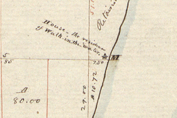

Joseph Fletcher, "Plat of Township No. III South, Range No. XI East," (1817).
Image courtesy Bureau of Land Management.


Treaty of St. Joseph (1827)


The purpose of this treaty was, as stated in its opening line, "to consolidate some of the dispersed bands of the Potawatamie Tribe in the Territory of Michigan at a point removed from the road leading from Detroit to Chicago, and as far as practicable from the settlements of the Whites." The agreement, signed September 19, 1827, ceded several Michigan reservations including two in present-day Southfield, known as Seginsiwin's Village (RA#135) and Tonquish's Village (RA#136). In exchange, the Potawatomi received a 99-square-mile reservation on the border between St. Joseph and Kalamazoo Counties.
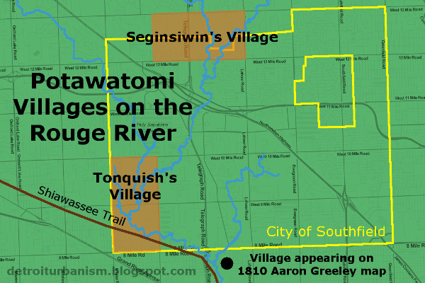

At the bottom of the above image, there was a village that was never part of any reservation. It appears on Aaron Greely's 1810 survey of private claims, labeled "Chippawa Village." This spot is now the Riverford Heights subdivision on Detroit's west side. It contains streets named Chippewa and Cherokee, and used to have Oneida and Ottawa Streets before they were renamed. It is very doubtful that Cherokee or Oneida ever occupied this area.
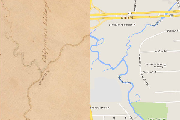

The Riverford Heights subdivision, Detroit, in 1810 and today.
1810 image courtesy Archives of Michigan.
(Source.)


Treaty of Washington (1836)


The 1807 Treaty of Detroit created four reservations at the northern end of Lake St. Clair for the Swan Creek and Black River bands of Chippewa Indians. These parcels were ceded by the Treaty of Washington, signed May 9, 1836. Two of them were in present-day St. Clair County, and the other two--the Salt River reserve (RA#215) and Auvase Creek reserve (RA#216)--were in what is now Chesterfield Township. The Auvase Creek site was known as McCoonse's Village. Its chief, Eshtonoquot ("Clear Sky"), was commonly known as Francis McCoonse. According to researcher Steve Brokenclaw, "His Celtic-sounding surname was actually an Anglicized version of his father's Ojibwe name [Macounce]."
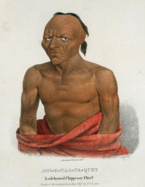

Eshtonoquot (Francis McCoonse), a signatory of the Treaty of Washington.
Image courtesy New York Public Library.
(Source.)

According to the Treaty of Washington, the U.S. was to sell the four reservations and forward the proceeds to the tribe, minus the costs incurred in the process. The tribe would also receive a new 8,320 acre reservation "west of the Mississippi or northwest of St. Anthony's Falls" that had not yet been located at the time of signing. The sale of the ceded lands took place May-June 1839.


Treaty of Upper Sandusky (1842)


This was the final treaty by which Indian land in Metro Detroit was ceded to the U.S. The Wyandot's Huron Township reservation (RA#260) and another in Ohio were given in exchange for a 148,000 acre reservation west of the Mississippi. The exact location of the new reserve wasn't finalized when the treaty was signed on March 17, 1842. The U.S. would also provide annuities and help defray the costs of moving, providing a school, a blacksmith, and an interpreter. The treaty also relieved the tribe's debt, which had long been used as a tool in obtaining Indian land. In 1803, President Thomas Jefferson wrote, "We shall push our trading uses, and be glad to see the good and influential individuals among them [the Indians] run in debt, because we observe that when these debts get beyond what the individuals can pay, they become willing to lop them off by a cession of lands."

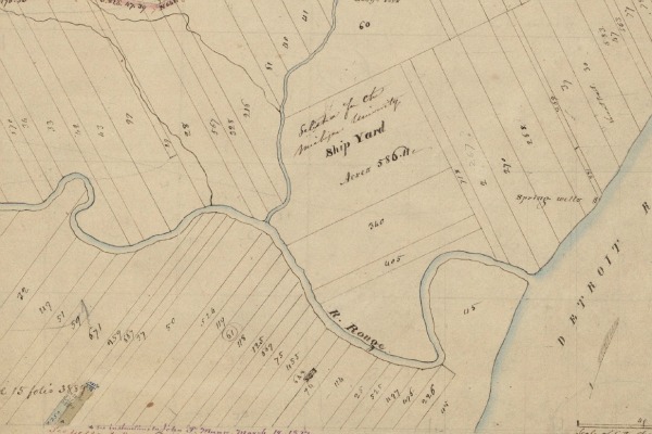
The Wyandot reservation appears on Orange Risdon's 1826 map of the Michigan Territory (below). Also indicated are the sites of Maguaga, Brownstown, and Blue Jacket's estate.
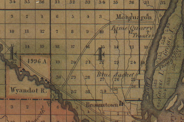

Orange Risdon, "Map of the surveyed part of the territory of Michigan" (1826).
Image courtesy Saline Area Historical Society.
(Source.)

A portion of Metro Detroit's last Native American reservation is now occupied by the 1,756-acre Oakwoods Metropark.


Epilogue: After Detroit


As you take the time to acknowledge the First Nations who once owned this land and fought to protect it, please also remember that these people are not lost shadows of history. No, they're not "extinct." The tribes formerly of Metro Detroit remain active, sovereign, and very much alive.
  • The Detroit bands of Ottawa who left in 1763 moved to Ohio. Later treaties moved them to Kansas, and then to Oklahoma, where they live today.
  • The Detroit Potawatomi were forced to relocate to Kansas in 1840, but apparently escaped back to Michigan, where they obtained new land and now exist as the Nottawaseppi Huron Band of the Potawatomi.
  • Although the Black River and Swan Creek Bands of Chippewa had agreed to move in 1836, only Chief McCoonse and a relatively small group actually migrated to their Kansas reservation. Many refused to leave Michigan and simply joined the Saginaw Chippewa, who obtained a reservation in Isabella County in 1855, where they still live.
  • The Detroit Wyandots moved to Kansas in 1842, then to Oklahoma in 1855. Their nation remains headquartered in Wyandotte, Oklahoma.
The closest reservation to Detroit is Walpole Island, Ontario. The fifty-three square mile island in Lake St. Clair was originally Chippewa territory and remains unceded land. Today it is home to more than 1,800 Chippewa, Potawatomi, and Ottawa citizens.

Monday, February 15, 2016

Detroit's Ribbon Farms: Shaping the Future Metropolis


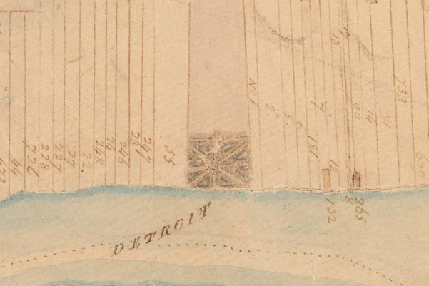
Detail from Aaron Greeley's Map of Private Claims on
Lake St. Clair, the Detroit River and Lake Erie, 1810.
Image sourtesy Seeking Michigan.
(Source.)

A distinguishing feature of early Detroit and other French settlements in North America is the way farmland was divided into long, narrow strips commonly referred to as ribbon farms. In Metropolitan Detroit, these farms were established on both sides of the Detroit, Rouge, and Clinton Rivers, as well as on Conner's Creek and the shores of Lake St. Clair. They are found elsewhere in Michigan, in Monroe, Saint Clair, Cheboygan, Mackinac and Chippewa Counties.

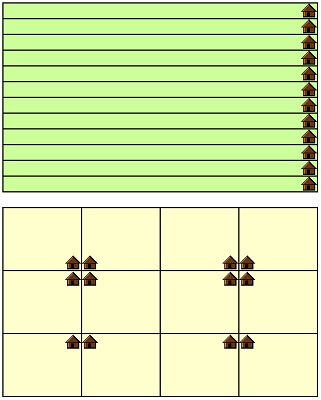
Dividing riverfront and lakeshore land in this way had two important advantages. First, it provided access to the water, the primary mode of transportation, to the maximum number of families. Second, it placed each farmhouse at a minimum distance from one another and from the fort at the center of the settlement. Visitors to early Detroit noted that the continuous row of houses along the river created the impression that the settlement was larger than it really was.


Twelve farms of equal area, each containing one house,
divided into ribbon farms (top) and into a simple grid (bottom).

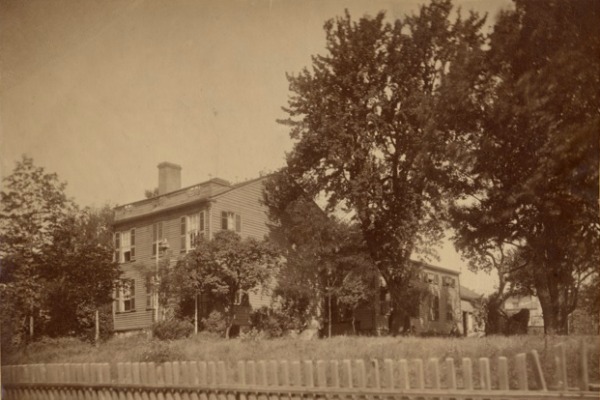
A typical farm in early Detroit contained a house close to the water, and a road between the house and the shore. Orchards of pear, apple and cherry trees were characteristic of the old French farms, grown either in front of or behind the farmhouse. "Almost every farmer had from one to half a dozen" pear trees, wrote historian Silas Farmer. Bela Hubbard in the 1880s described old pear trees that had reached up to eighty feet in height.


This house was built ca. 1835 at the foot of the Labrosse Farm, roughly between
Seventh and Eighth Streets in Detroit. To the right are old French pear trees.
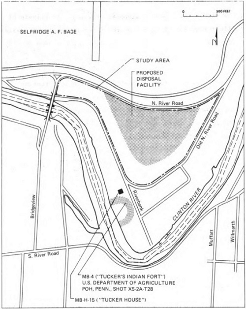
Image courtesy Burton Historical Collection, Detroit Public Library.
(Source.)

The main cereal crops grown in the early days were Indian corn, wheat, and oats. Farmers also kept vegetable gardens, raised livestock, and even grew grapes for wine making. Cattle grazed on the farmers' land or on the public land north of the fort. The ribbon farms extended into the dense hardwood forest that surrounded the settlement, but these rear portions of the lots were not cultivated.

Most farms were two or three French arpents wide (1 arpent = 191.831 feet), but some measured five arpents across or more. All farms on the Detroit River were forty arpents deep--about one and a half miles long. The borders between individual farms were marked by ditches.

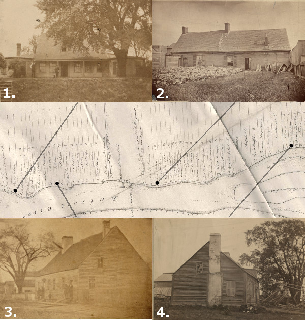
Houses from Detroit's old "ribbon farms."
1. The Labadie House. Built circa 1780, demolished 1910.
(Source.)
2. The Moran House. Built circa 1734, demolished 1886. (Source.)
3. The Lafferty House. Built in 1747, burned or demolished 1861. (Source.)
4. The Hamtramck House. Built 1802, demolished 1898. (Source.)
Images courtesy Burton Historical Collection, Detroit Public Library.
Map: Detail from McNiff’s 1796
Plan of the Settlements at Detroit.
Image courtesy Detroit Historical Society. (Source.)


Early Grants


When Antoine de La Mothe Cadillac founded Fort Pontchartrain in 1701, the French Canadian settlers were dependent on trade with Native Americans and supplies from Quebec for food. Although some crops were grown on the public grounds, no farms were granted to white settlers for several years. Cadillac had not yet been authorized to make such concessions, and there was little available land close to the fort, which was flanked on the east and west by Miami and Huron villages, and an Ottawa village farther upstream.


Settlements along the Detroit River, circa 1702.
From south to north: Huron, French, Loups, and Ottawa.
Miamis soon joined the Loups and lived together in the same village.
Image courtesy Burton Historical Collection, Detroit Public Library.

(Source.)

Peace among the First Nations gathered at Detroit was tenuous, and the locations of villages shifted after major conflicts. In just a few years, the Miami had moved to Ohio, and the Ottawa relocated across the Detroit River. By 1707, Cadillac had the authority to grant land concessions, and the first farms allotted were east of the fort, on the land left vacant by the Miami and Ottawa.


Plan of Detroit in 1731 by Henri-Louis Deschamps de Boishébert,
probably the earliest depiction of Detroit's ribbon farms.
Image courtesy Wayne State University Press.
(Source.)

Researchers have identified the recipients of thirty-one farm grants (PDF) made by Cadillac between 1707-1710. These "grants" came laden with multiple obligations and restrictions. Each owner was required to:
  • Pay Cadillac annual dues of five livres
  • Pay an annual fee of ten livres for the right to trade
  • Refrain from hunting hares, rabbits, partridges or pheasants (other hunting was allowed)
  • Grind all grain at Cadillac's mill and pay the associated fees
  • Begin improvements on land within three months
  • Obtain Cadillac's permission to sell land, and Cadillac had first right to buy
  • Provide timber for the stockade or shipbuilding if requested
  • Not work as blacksmith, cutler, armorer or brewer without a permit
  • Not sell liquor to Native Americans
  • Plant a maypole before the door of Cadillac's home each spring (!)

Cadillac was forced to leave Detroit in 1711, having been "promoted" to the office of Governor of Louisiana. Few if any grants were made for twenty years while the colony languished.


French Growth and British Occupation


King Louis XV, eager to see Detroit become self sufficient, pressured its commandants to continue leasing farmland in the 1720s and 1730s. In the relative peace that came with the end of the bloody Fox Wars (1712-1733), additional land grants were made between 1734 and 1736. Farmers began to build houses on their land around this time.

A dispute between the Huron and Ottawa in 1738 led to the Hurons' abandonment of their village west of the fort. The French divided the former Huron settlement into more ribbon farms in the 1740s, expanding the colony downstream until it met the border of the land owned by the Potawatomi, whose village was located at what is now Riverside Park, near the Ambassador Bridge. The Hurons were eventually enticed to return to Detroit, settling across the river from their former village.


Detroit in 1749. (Source.)

France redoubled its efforts to expand the colony in 1749, promising new settlers not just land, but tools, animals and seed. Twenty French Canadian families arrived that year, establishing ribbon farms downstream from the fort on what is now the Canadian shore.

Following the takeover of Detroit by the British in 1760 and Pontiac's unsuccessful siege of the fort three years later, the remaining First Nations at Detroit began to sell and abandon their land. Whites who purchased this land divided it into the same ribbon pattern as the generations before them. It was during this period that Belle Isle was purchased from the Chippewa and Ottawa nations, and Grosse Ile from the Potawatomi. Ribbon farms spread both north along the western shore of Lake St. Clair and up the Clinton River, and south along the Detroit River to Lake Erie, moving inland along the Rouge River and the River Raisin.


The Private Claims


Click here for a larger version of this image.

What happens to private property when a brand new government takes over a 100 year old settlement with poor record keeping? That was the situation the United States government found itself in when Colonel J. F. Hamtramck took command of Detroit on July 11, 1796. Congress directed the creation of a Detroit land office in 1804 in part to register land claims, but there was only enough documentation to support eight titles.

The process was greatly simplified when Congress passed a law on March 3, 1807 ensuring that residents who had "settled, occupied and improved" land in the Detroit district "prior to and on the first day of July, 1796" would have their claim "granted, and such occupant or occupants shall be confirmed in the title to the same." In other words, if you had a house and/or farm on a parcel of land before July 1, 1796, the U.S. Government would recognize your ownership and issue you a deed. (No Native Americans could file claims because the 1795 Treaty of Greenville extinguished all Indian title to land within six miles of the Detroit River and the west end of Lake Erie.)


Ribbon farms along the Rouge and Detroit Rivers in 1817.
Image courtesy Bureau of Land Management.
(Source.)

Residents filed their applications at the Detroit land office and brought forth witnesses--usually neighbors--who corroborated their claims. Petitions were numbered in the order in which they were received, and the land was surveyed at the government's expense. When an application was approved, the property owner received a land patent. These were originally issued by the Treasury Department, then later by the General Land Office and signed by the President of the United States (at least until the 1830s). The application number was then designated as that parcel's Private Claim Number. Every ribbon farm has a Private Claim Number.

For example, the very first application processed by the Detroit land office was that of Elijah Brush, who happened to claim ownership of the first ribbon farm east of the fort. Upon approval, the Brush Farm was designated "Private Claim No. 1," and Mr. Brush was issued a land patent by the United States Treasury Department.


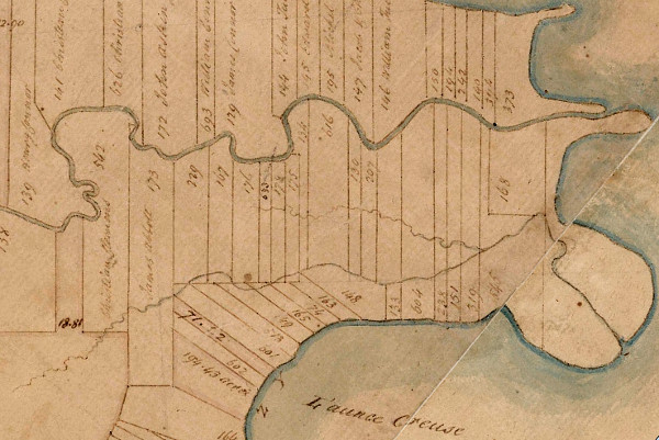
Private Claims on the Clinton River in what is now Harrison Township.
The numbers designate each parcel's Private Claim Number.
Detail from Aaron Greeley's Map of Private Claims on
Lake St. Clair, the Detroit River and Lake Erie, 1810.
Image sourtesy Seeking Michigan.
(Source.)

Although the original French grants only extended inland by 40 arpents (about one and a half miles), a modern map of the Private Claims in Detroit shows them being twice that length. The reason for this is that the farmers on the U.S. side of the Detroit River petitioned Congress in 1807, pleading for extensions to their claims. They argued that these forested back lots were their only source of wood for fuel and for the construction of fences and buildings. Congress passed a law in 1812 allowing these landowners to claim a full 80 arpents in depth, as long as the land behind their original 40 arpents was unoccupied and unclaimed. The Private Claims recognized today extend almost three miles inland, but the French Canadian farmers of eighteenth century Detroit never occupied lots of this size.


Subdivisions


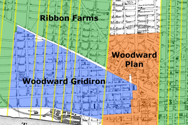
Detroit enjoyed a rapid expansion following the opening of the Erie Canal in 1825, enticing the owners of the ribbon farms to turn their land over to urbanization. Former fields, orchards and meadows were subdivided into building lots, streets and alleys. Augustus Woodward's famous street plan was abandoned before any of the ribbon farms were incorporated into the city. A simpler plan of rectangular city blocks aligned with Woodward and Jefferson Avenues was followed for a time on the city's near west side, and portions of some ribbon farms were subdivided in accordance with it. This gridiron pattern disregarded the boundaries of the ribbon farms, resulting in a multitude of fractional lots. This system was also dropped, and farms were then subdivided on an individual basis. From then on, the boundaries of streets and building lots would conform to the outlines and positions of the old French land claims.


Ribbon farms dictated the orientation of most of Detroit's streets within three
miles of the river. Borders of the farms are highlighted in yellow. The base map
is from 1872, long before urban renewal destroyed the street grid.
(Source).

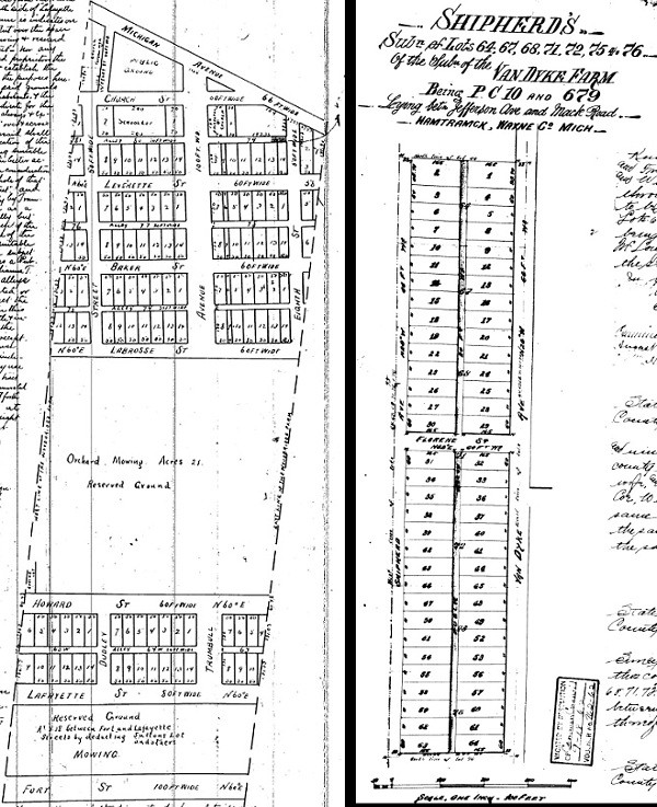
A farm owner who wanted to subdivide their land was required to submit to the county a plat indicating the outlines and dimensions of lots, streets and alleys. When approved, streets and alleys became public property, and the proprietor was the owner of the individual lots, which could be sold as they saw fit. Farmers near Detroit tended to subdivide their land in sections rather than all at once.

Left: Subdivision plat of part of the Woodbridge Farm in Corktown, 1858. Blocks are aligned with the "Woodward Gridiron" rather than the farm's borders. The area between Howard and Labrosse Streets was still an orchard and not yet divided into lots. (Source.)
Right: Subdivision plat of part of the Van Dyke Farm in West Village, 1890, in line with the farm's borders. Florene Street has since been renamed St. Paul Street. (Source.)

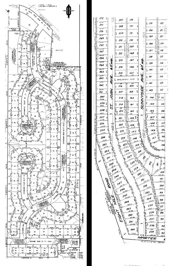
Private Claims in the suburbs were subdivided well into the 20th century, as the following two examples show.

Left: River Bend Subdivision No. 1 (1999), part of Private Claim No. 207 in Harrison Township. (Source.)
Right: Edward Rose Subdivision (1952), part of Private Claim No. 656 in St. Clair Shores. (Source.)
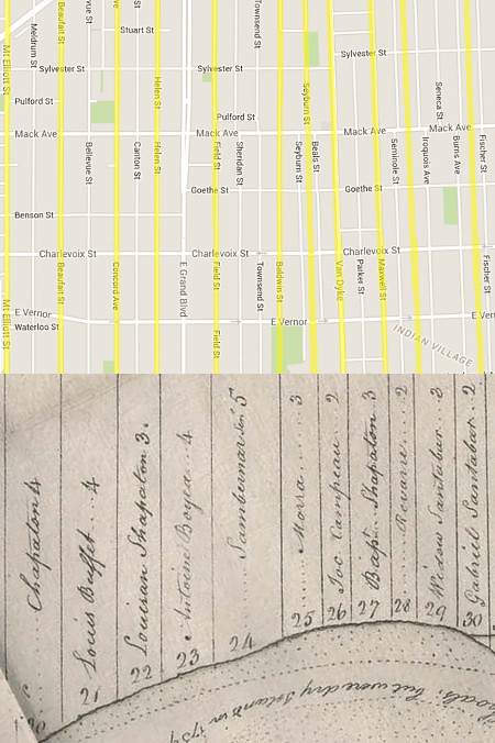
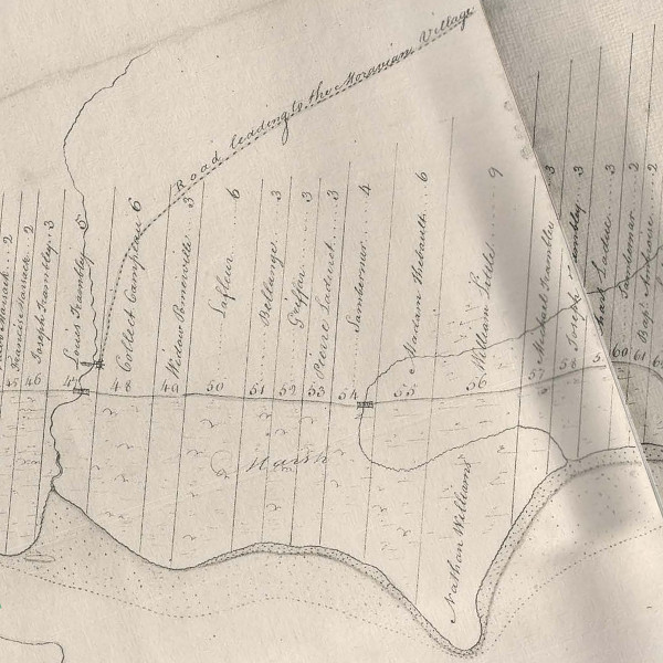
Disparity among the widths of Detroit's ribbon farms created a lack of uniformity in the city's street grid. The French grants normally ranged anywhere from two to five arpents wide, resulting in irregular city blocks when developed. The image below shows an example on Detroit's east side. The lower half is from a 1796 map, indicating the widths of farms in arpents above each owners' name. The upper half is a modern map of the adjacent area. Ribbon farm borders are highlighted in yellow.


Old map: Detail from McNiff’s 1796 Plan of the Settlements at Detroit.
Image courtesy Detroit Historical Society. (Source.)

As with Native American trails, the French ribbon farms have imprinted the landscape in ways that survive long after their makers have left. The history they have made here is still very much alive and with us today.


* * * * *


Click and hold the white divider in the images below and slide left and right to compare old maps with satellite views and to see how ribbon farms influenced urbanization and suburban sprawl in Metro Detroit.


Private Claims in what is now Grosse Pointe Woods and Grosse Pointe Shores.
Old map: detail from J. Fletcher's 1817 survey of township I south range XII east.


The rear border of Private Claims No. 317 & 318, ribbon farms on the Rouge
River, create this anomaly on the Detroit-Dearborn border, shown here in red.
Old map: detail from J. Fletcher's 1817 survey of township II south range X east.


Ribbon farms in what is now St. Clair Shores.
Old map: detail from an 1875 atlas of Macomb County.
(Source.)


The City of Harper Woods lies on the extensions of ribbon farms on Lake St. Clair.
Old map: detail from an 1876 atlas of Wayne County.
(Source.)

Tuesday, January 19, 2016

Retracing Detroit's Native American Trails

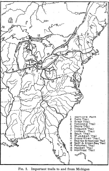
The most fascinating thing to me about Native American trails isn't just that Detroit was a hub in a continent-wide network of footpaths worn into the earth centuries before Cadillac or Columbus--it's that some of these paths have been preserved as modern roads and highways, and today we can still walk in the footsteps of the civilizations that came before us.


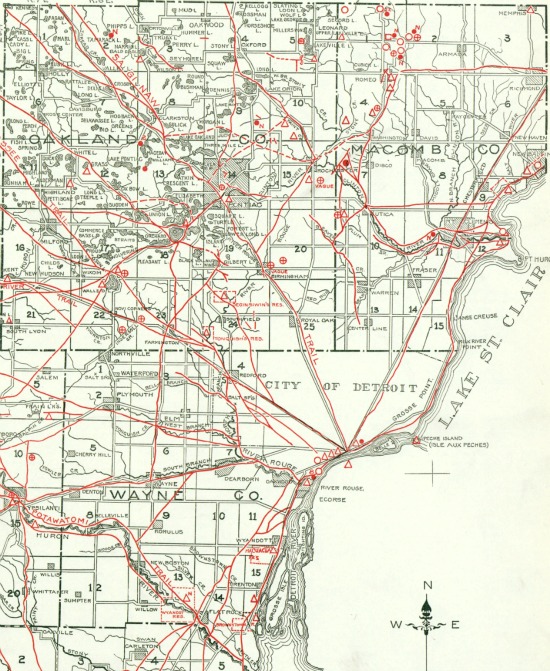
From Archaeological Atlas of Michigan, but Wilbert B. Hinsdale. (Source.)

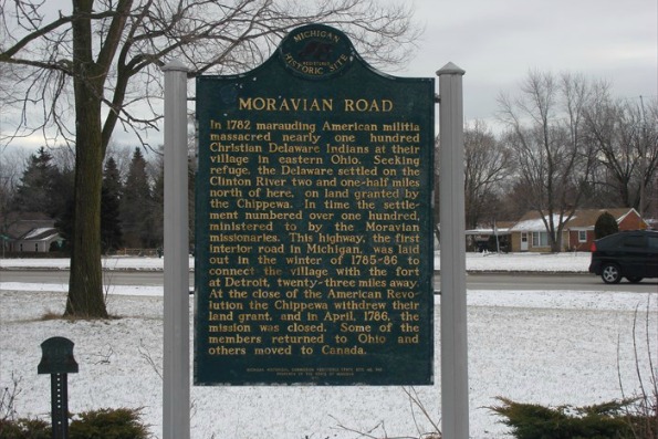
I first learned about this on a childhood visit to my grandparents' house in Clinton Township. There was a historical marker a few blocks from their subdivision, and I asked my grandpa what it said. He told me that it said Moravian Road, where it was located, was originally a trail cut through the wilderness by Delaware Indians to connect their Moravian village to Detroit.


The historical marker at Moravian Road and Metropolitan Parkway.
Image courtesy waymarking.com.
(Source.)

The Moravian Trail is young, being "only" 330 years old. The establishment of Fort Pontchartrain in 1701 likely influenced the locations of some older trails, but many certainly existed since the time when the Mound Builders lived in southwest Detroit more than a millennium ago.


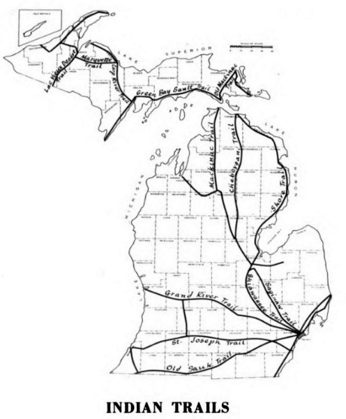
From Michigan Highways: From Indian Trails to Expressways, by Philip P. Mason. (Source.)

These trails were narrow, single-file passageways simply created by the earth being trampled along the paths most frequently traveled. But in a way, it was the land itself that created these highways. The Earth predetermines where humans will settle (on arable land, close to waterways convenient for transportation) and the most logical path between those settlements (high, dry, level land, avoiding swamps and other obstacles, and crossing rivers at their most narrow or shallow points). Some trails in Michigan trace glacial moraines deposited ten thousand years ago. Archaeologists hypothesize that roaming herds of animals were the first to travel these paths, showing the way to the hunters who followed them. When the Europeans came, they found that the best places to settle were the sites of former Native American villages, and they utilized and maintained the same trails between them.


From Archaeological Atlas of Michigan, but Wilbert B. Hinsdale. (Source.)

You have probably already heard about roads that used to be "Indian paths." This isn't a new revelation. The question I'm interested is, How do we know that a certain road was once a Native American trail?

One source is the accounts of early settlers. The Pioneer Society of the State of Michigan was founded in 1876, the year of the United States' first centennial, to preserve the memories of the first white settlers of the state's interior before that generation had completely disappeared. They described seeking out and relying on the trails for their own needs, and later expanding them into wagon trails and roads.

But we have even better proof.


The U.S. Government Surveys


Following the 1807 Treaty of Detroit, all land in southeast Michigan that had not been settled upon before 1796 or designated an Indian reservation became property of the United States Government. In order for the land to be sold or used as payment, it needed to be surveyed. The first surveyors in southeast Michigan divided the land into six-mile by six-mile townships. At a later date these townships were subdivided into one-mile square sections. While imposing this massive grid onto the landscape, driving posts into the ground every half mile along their paths, surveyors had been instructed to note, among other observations: the condition of the soil and land; the type of timber or other growth; the boundaries of rivers, lakes and other bodies of water; and the locations of "all roads and trails, with the courses they bear." In theory, the surveyors' field notes should contain this data.

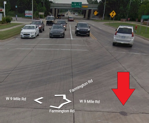
Take for example Farmington township, subdivided by Samuel Carpenter. His field notes show that he set a marker (probably a cedar post) at what is now the intersection of Farmington Road and Nine Mile Road on May 11, 1817. The post is long gone, but its exact location has been continuously preserved for nearly 200 years. Today, a modern surveyors' mark is on this very spot, protected by a cast iron cover:


A survey marker in the intersection of Farmington and Nine Mile Roads.
Image courtesy Google Street View.

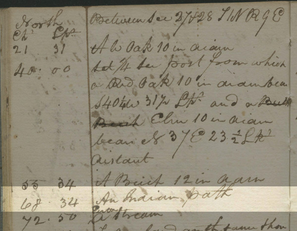
The following day, Carpenter ran a line north from this point, carefully measuring the land with a sixty-six foot surveyor's chain. Below are the notes he took while running this line:


Image courtesy Seeking Michigan. (Source.)

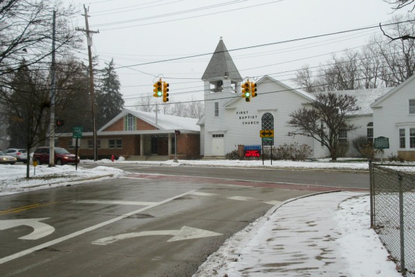
We can see in the highlighted text that at 68 chains, 34 links (4,510.44 feet) north from the Farmington/9 Mile marker, Carpenter noted an Indian path. This is that spot today:


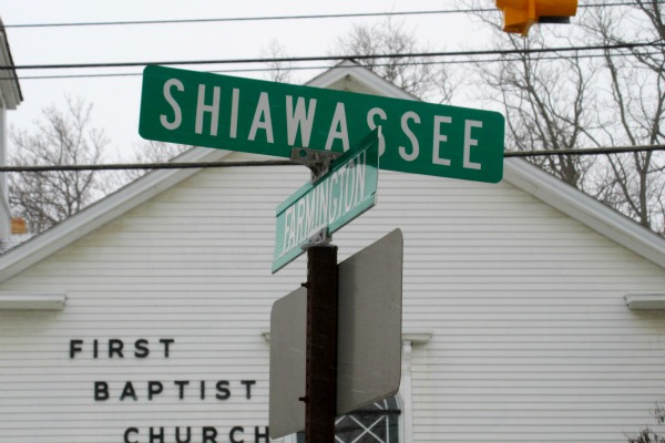
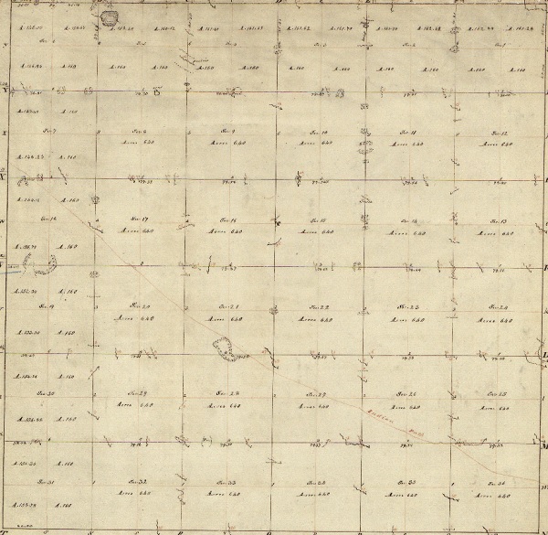
This is Shiawassee Street, once part of the Shiawassee Trail. Google Earth places the point 4,510.44 feet north of Carpenter's survey marker inside of the First Baptist Church, but this road was clearly a continuation of the old trail. Carpenter repeatedly crossed over this trail in his survey, but you don't need to read through his field notes to decode its path. The surveyors themselves drew up plats of the townships they subdivided. Below is Carpenter's plat of this township, years before it contained a single white settler:


Plat of Township I North, Range IX East of the Meridian, Michigan Territory.
The faint red line running diagonally is a Native American trail.
Image courtesy Bureau of Land Management, General Land Office.
(Source.)

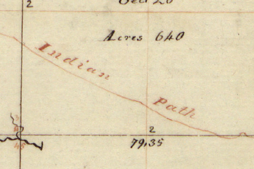
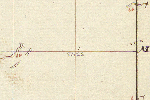
The survey plats often indicated trails with a red line.


The Shiawassee Trail in Farmington, now Shiawassee Street.

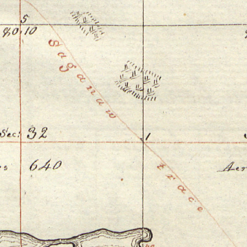
Sometimes the trails were labeled.


The Saginaw Trail in Independence Township, now Dixie Highway.

Usually paths were only indicated by a dotted line paired with a solid line, and only where they intersected the surveyor's grid.


Pieces of the Great Sauk Trail in Canton Township, now Michigan Avenue.

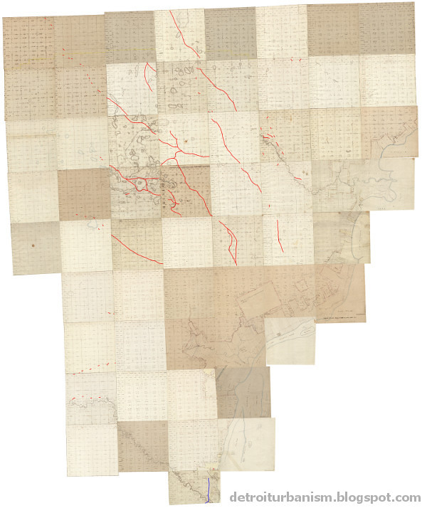
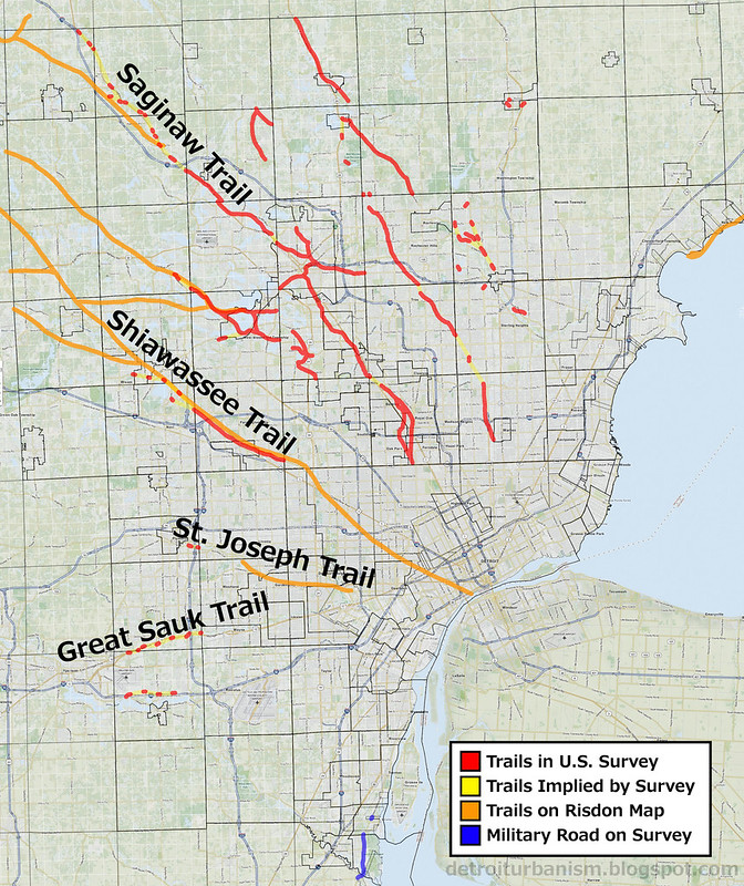
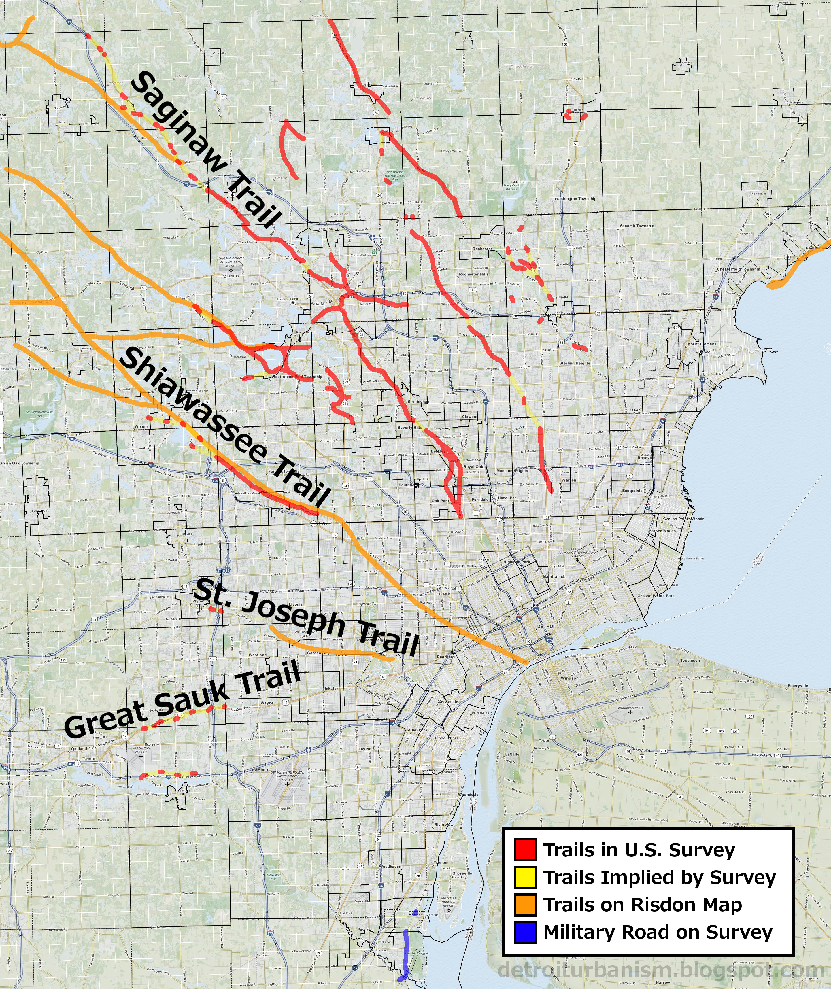
We know exactly where many Native American trails were because their locations were carefully measured in relation to markers that still exist, by eyewitnesses who were trained surveyors, years before any of the land was purchased, developed, or inhabited by white settlers. Because the grid drawn by the surveyors persists--it is what our "mile road" system is based on--it is possible to superimpose the surveyors' plats over a modern map of Metropolitan Detroit and retrace the old trails with great accuracy. Here is a composite of all fifty-eight plats that comprise the tri-county area with trails highlighted in red. Near the bottom is the military road to Urbana, Ohio, denoted in the surveys, highlighted in blue.


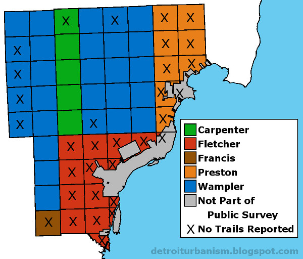
This image isn't quite ready to trace onto a modern map. There are some obvious gaps in the trails. Why are most of Macomb and Wayne Counties devoid of any paths? To find the answer, I looked into who was doing the surveying. All of the townships that comprise the tri-county area were subdivided by five surveyors (and their crews): Samuel Carpenter, Joseph Fletcher, Joseph Francis, William Preston, and Joseph Wampler. Below is a map showing who subdivided which township. Townships that did not indicate any Native American trails on their plats or in their field notes are marked with an "X." Do you notice any patterns?


Surveys of Wayne, Oakland and Macomb Counties, 1815-1823.

Isn't it strange that four out of five townships surveyed by Carpenter and Wampler contain trails, while Fletcher, Francis and Preston show a combined total of zero? Maybe these men misunderstood their instructions. Negligence might also have played a role. Fletcher was originally contracted to survey an area close to the Points of Origin for the Michigan Survey, but his work was so flawed that it had to be redone by Wampler. Unfortunately, Fletcher's surveys included all of the modern City of Detroit. We may never accurately know the locations of the Native American trails in the city.


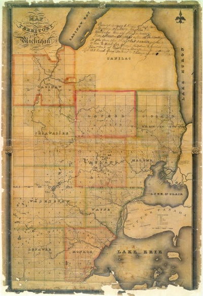
The Orange Risdon Map


In the 1820s, Michigan was on the verge of a massive influx of both homesteaders and speculators seeking cheap land. The southeast part of the territory had been surveyed and was up for sale. Orange Risdon, himself a professional surveyor and well-traveled explorer of the area, tried to capitalize on the mass immigration by producing a detailed map of the region. He utilized government surveys and his own firsthand knowledge to create a map that would help land purchasers make informed selections.


Map of the surveyed part of the territory of Michigan, by Orange Risdon. (Source.)

Risdon published an advertisement in the October 1, 1824 edition of the Detroit Gazette in order to gain early subscribers of the map, which would be published the following year. In the ad, Risdon stated:
"The publisher, having spent some time in exploring that junction of the territory embraced in his map, will be enabled to locate the most important Indian paths, which as they were made by those who were acquainted with every part of the country will be an important guide in the future location of our roads."
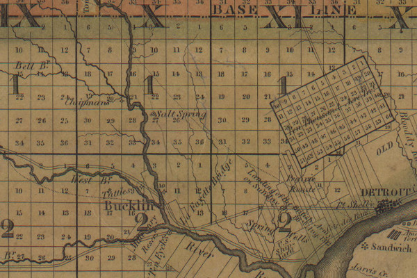
Risdon's map uses dotted lines to indicate Native American trails, including the portion of the Shiawassee Trail missing from Fletcher's surveys. Some trails had already been replaced by straight, surveyed roads by the time the map was produced, but enough remained to fill some of the surveyors' omissions.


Detail from Map of the surveyed part of the territory of Michigan. (Source.)
Near Bucklin (modern Dearborn) is the St. Joseph Trail.
Leading northwest out of Detroit is the Shiawassee Trail.

Below is an image that superimposes the trails seen on both Risdon's map and the U.S. surveys onto a modern map of Wayne, Oakland and Macomb Counties.


The Native American trails of Metropolitan Detroit.
Click here for a larger version of this map.


Important Trails Around Detroit


The Saginaw Trail • Ran northwest out of Detroit to the Saginaw River. The site of the settlement at Pontiac was chosen because it was where this trail crossed the Clinton River. North of Pontiac, the Saginaw Trail is mostly preserved as the Dixie Highway. But the winding footpath between Detroit and Pontiac was supplanted by the straight and rigid Woodward Avenue in the 1820s. Even this incarnation of Woodward is not quite the same as today's route. There used to be an abrupt jog in the road in Royal Oak to avoid a swamp. The road turned right at what is now Lafayette Avenue, which used to continue to what is now Crooks Road, where it turned left, then continued to Pontiac. I believe that a portion of Lafayette Avenue traces the old Saginaw Trail, which was bypassing the same swamp. Below is an animation showing this road in the 1817 government survey, an 1872 map, and a modern satellite image.


The Great Sauk Trail • Also called the Chicago Road. It ran west from the Rouge River near Detroit, terminated at Rock Island, Illinois on the Mississippi River. In the 1820s, the trail was used as the foundation of a military road to Fort Dearborn at what is now Chicago. This road exists today as US-12.

The St. Joseph Trail • Also called Territorial Road. It connected the Rouge River near Detroit to the St. Joseph River of Lake Michigan, passing through Jackson, Battle Creek and Kalamazoo. The highway that coincided with the trail was originally marked as US-12 before that designation was transferred to the Chicago Road in 1962.

The Shiawassee Trail • Began just west of Detroit according to Risdon's map, ran northwest and connected to the Shiawassee River at the present site of the Village of Byron. It then followed the Shiawassee River downstream to the Saginaw River. The site of Farmington was chosen by its founder Arthur Power because it was where the Shiawassee Trail crossed the Rouge River.

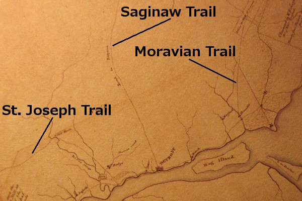
The Moravian Trail • Cleared of timber in the winter of 1785-86 by Delaware (Lenape) Indians who were members of the Moravian Missionary on the Clinton River. The trail ran southwest from the mission along the Clinton River likely where Moravian Road is today. It continued south through what is now Warren, then took a slightly southeasterly course to Connor's Creek on Detroit's east side. The Fort Gratiot Turnpike later replaced the trail as the northeasterly road out of Detroit.

(There are other roads I haven't mentioned which, even though they appear on Hinsdale's map at the beginning of this entry, may not actually be native American in origin. These will be discussed in a future post.)


Detail from Patrick McNiff's Plan of the Settlements at Detroit, 1796. The Moravian Trail ended at Conner's (formerly Trombley's) Creek close to the Detroit River.
Image courtesy Detroit Historical Society.
(Source.)


Native American trails near Detroit in 1797.
Detail from
A Rough Sketch of Part of Wayne County Territory by Robert King.
Source: Brian L. Dunnigan,
Frontier Metropolis: Picturing Early Detroit, 1701-1838.

Our map was not a blank canvas when Cadillac landed in 1701. Sometimes we assume that the tribes pushed out of southeast Michigan left without a trace, even as we drive along the pathways they built, unaware of their origin. The land was worked and shaped by those who had preceded us since time immemorial, and the Earth bears witness to this fact.

Monday, January 4, 2016

Other Mounds in Metro Detroit

Although I have yet to discuss "urbanism," I'd like to write a little more about other Native American earthworks once located in Metropolitan Detroit. There were too many to fit into in my last entry, but their stories are an important part of our history.

* * * * *

Hinsdale's Atlas


The first attempt to document all known Native American archaeological sites in the state was Wilbert Hinsdale's Archaeological Atlas of the State of Michigan in 1931. Accepted informants ranged from historical documents to "hearsay sources." Hinsdale and his collaborators examined claims and visited sites to determine plausibility, and concluded that there had been more than 1,068 mounds and 113 earthworks in Michigan, but that fewer than 5% "have escaped mutilation." Outside of Detroit, the largest earthworks in the state were found in Grand Rapids and Port Huron.

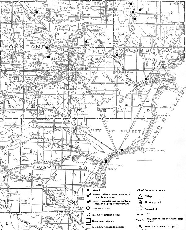
The following sites in Metropolitan Detroit were included in Hinsdale's atlas:
  • Wayne county--In addition to the Springwells Mound Group covered in my last post, Hinsdale showed a mound by the Detroit River east of downtown. I have not found any information on it.
  • Oakland County--Hinsdale counted five mounds, including "a group in Groveland Township, near the center, and another in the eastern half of Orion Township. The exact number in either group is not a matter of record." A 1960s subdivision in Bloomfield Township contains streets named Indian Mound Road and Indian Mound Trail, but no such features appear near this location on Hinsdale's map.
  • Macomb County--Here there were once twenty-six mounds, eight circular enclosures, and one rectangular enclosure. According to Hinsdale, "All we know of the extensive inclosures [sic] that had been built in unusual designs in Macomb County is gathered from the literature." In other words, they had all been destroyed.


From Archaeological Atlas of Michigan, by Wilbert Hinsdale. (Source.)

Some of the following mounds and earthworks appear in Hinsdale's atlas, others do not.


The Prairie Mound and Mound Road, Detroit


In the mid-19th century, Hamtramck was a large and mostly undeveloped township with borders extending from Woodward Avenue to Connor's Creek, and from the Detroit River to Eight Mile Road. Around 1865, Civil War veteran Philetus W. Norris purchased a large tract of land in the township close to a sandy hill he called the Prairie Mound. An 1876 history of Wayne County described the location:
"The low but fertile glades and blue joint prairies...were alike the chosen hunting grounds of the prehistoric Mound Builders and Indians... The famous Prairie Mound, of some four acres, was ever a chosen haunt for the Indians, trappers and herders; the site of countless broils and revels, and probably the torturing of prisoners--certainly a bone tumulus of the unknown dead."
Norris convinced the Detroit & Bay City Rail Road to come through his property in order to help establish a village there. He wanted to call his settlement "Prairie Mound," but the railroad named their stop "Norris," and the subsequent village plat and post office bore the same name. The original plat contained a Prairie Street and Mound Street, but they have since been renamed Iowa and Davison Streets, respectively. However, the north-south road on the western border of the village was named Mound Avenue. It coincides with today's Mound Road.

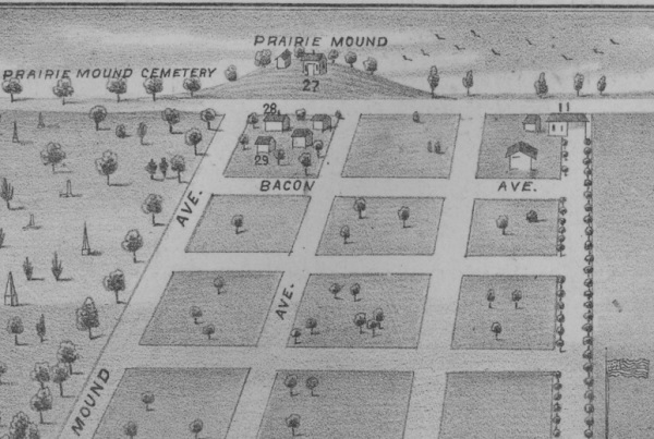
The Prairie Mound would have stood northeast of the intersection of Mound and Seven Mile Roads. It appears on this 1876 "bird's eye view" of Norris:


From Illustrated Historical Atlas of the County of Wayne, Michigan, H. Belden & Co.
Image courtesy University of Michigan.
(Source.)

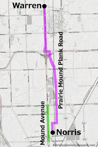
In 1873, Philetus Norris incorporated the Prairie Mound Plank Road Company and was authorized to build this toll road to Warren. To trace the path of the Prairie Mound Plank Road today, begin at the intersection of Nevada St. and Mt. Elliott St. and head north; turn east on 7 Mile Rd., north on Sherwood St., west on 11 Mile Rd., and north on today's Mound Rd. to Chicago Rd., the historic center of the Village of Warren. Today's Mound Road runs from Caniff Ave. in Detroit to Auburn Rd. in Shelby Township, and coincides with the former "Mound Avenue" in Norris and the northern segment of the Prairie Mound Plank Road.


The routes of Mound Ave. and Prairie Mound Plank Rd., circa 1876.

The Prairie Mound was probably not a human-made burial mound. In his 1913 Geological Report on Wayne County, William H. Sherzer wrote:
"The so-called 'Prairie Mound' (in) Hamtramck township, is simply a crescent-shaped sand dune, some 9 to 10 feet high and about 500 feet in length. Upon this William A. Ennis built a house and barn about the year 1865 and came across bones associated with Indian relics,--but whether of the Mound Builder type or not is not known."
Whatever the nature of this mound, there is no trace of it left. Standing at approximately this location today is Lou's Coney Island at 19100 Mound Road, Detroit.


Tucker Farm Earthwork, Harrison Township


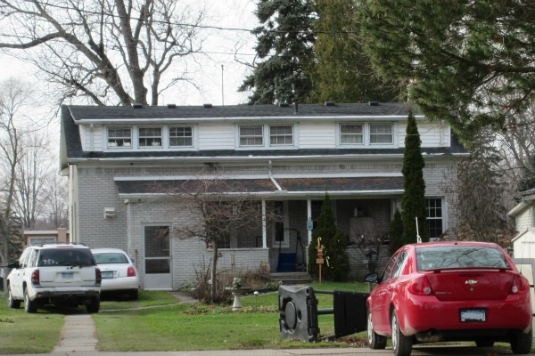
William Tucker was eleven years old in 1753 when a band of Chippewas raided his family's settlement in Stover, Virginia and killed his father. The Chippewas kidnapped Tucker and his brother, adopted them as members of the tribe, and brought them to their homeland in what is now Clinton and Harrison Townships. When Tucker was allowed to leave the tribe at the age of eighteen, he traveled to Detroit and used his knowledge of Native American dialects to work as a guide and interpreter for Detroit merchants, the British government, and Native American tribes. Twenty years later, in 1780, the Chippewas rewarded Tucker for his friendship and honesty in business with a large land grant on the north side of the Clinton River. He built a log cabin on this land in 1784. The home has since been extensively modified, receiving a brick facade in the 20th century. But the log cabin remains hidden beneath, and appears to be the oldest surviving house built in Michigan outside of Mackinac Island.


The William Tucker House, 29020 Riverbank Street, Harrison Township.
This home became a Michigan State Historic Site on February 23, 1981.

Having been raised by the Chippewa on this land, Tucker knew the area well. The fruitful hunting grounds and the fertile soil made it an ideal place to homestead. In fact, the site Tucker selected had already been an old Native American settlement. He built his cabin next to an old circular earthwork similar to the one found in Springwells. Previous inhabitants of the area had grown maize on the same spot.


The site of Tucker's cabin and the now-lost "fort." (Source.)

Samuel Brown's The Western Gazetteer; Or Emigrant's Directory, published in 1817, noted the existence of the Tucker Farm Earthwork, and Michael A. Leeson's History of Macomb County, Michigan, written in 1882, claimed that there were other such "forts" along the river on land owned by members of the Tucker family. Archaeologist Arnold Pilling, in researching this location (PDF), noted that the earthwork was still visible in an aerial photograph taken in 1940. But by the end of the decade, the entire area had been built over with riverfront cottages.


Northern Macomb County Earthworks


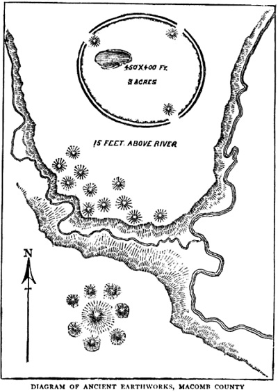
The largest of the circular earthworks of Macomb County was located on a branch of the Clinton River in Armada Township. It encompassed three acres and stood four or five feet high when described around 1830. It was surrounded by a dry moat created by the digging up of the earth for the embankment. A pond lay within the earthwork. According to Leeson's History of Macomb County, south of this "fort" were many small burial mounds, each containing the remains of one individual. On the other side of a nearby stream was a large burial mound, out of which grew a large oak, surrounded by a series of smaller mounds. Not far from this area were found scattered mounds made entirely of stone piled four feet high, each concealing the cremated remains of one individual. All of these earthworks were destroyed prior to 1882.


From Memorials of a Half-Century by Bela Hubbard.

Farther upstream was a smaller circular earthwork with its own set of burial mounds. Edwin P. Sandford of Romeo dug into one of them in 1880 and extracted the skeletons of three adults and three children. Set apart from the smaller mounds was a larger one four and a half feet high with a diameter of twenty feet. A large oak tree grew from this mound which, when cut down, was found to have been 240 years old. When described in 1882, the mound had not yet been greatly disturbed thanks to the massive roots left behind by the felled oak.


New Gnaddenhütten, Clinton Township


In 1781, a group of Christian missionaries from Ohio were arrested and brought to British-controlled Detroit to answer charges of supporting the American Revolution. These were the Moravians, a group of whites and Delaware Indians practicing a form of Protestantism that predated Martin Luther and had been revived by Count Zinzendorf of Moravia several decades before. While some Moravian leaders were in Detroit, the congregants left behind in Ohio were horrifically massacred by American militiamen. Although the Moravians in Detroit were exonerated of the charges of treason, they feared returning to Ohio. With the help of Chippewa Indians and Fort Detroit's commandant, Major Arent DePeyster, they found a new home on the Clinton River, half a mile west of what is today Mount Clemens. They arrived at the site of their future village on July 22, 1782, and named it New Gnaddenhütten.


New Gnaddenhütten was founded close to this spot on the Clinton River.

Brown referenced this location in his Western Gazetteer:
On the river Huron [the old name for the Clinton River], thirty miles from Detroit, and about eight miles from lake St. Clair, are a number of small mounds, situated on a dry plain, or bluff near the river. Sixteen baskets full of human bones, of a remarkable size, were discovered in the earth while sinking a cellar on this plain, for the missionary.
Strangely, the diary of David Zeisberger, the Moravians' minister, did not mention any mounds. But he did write that his group "found many traces that a long time ago an Indian town must have stood on this place," including "little hills where corn had been planted, but where now is a dense wood of trees two to six feet in diameter." Perhaps these "little hills" were exaggerated into "mounds" in the twenty years between Zeisberger's landing and Brown's research.


The Moravians' village was near the south bank of this bend in the Clinton River.

Also absent from Zeisberger's diary is an account of unearthing a large number of bones. Archaeologist Arnold Pilling has speculated that the Moravians very well could have encountered a mass burial since it was the site of an ancient village, but no cellar was dug for the mission. Instead, the cellar in question may have been one of the "out cellars" mentioned by the Moravians when describing improvements made to the land several years later (see "Six Archaeological Sites in the Detroit Area," Michigan Archaeologist, vol. 7, Sep. 1961).


Riviere au Vase, Chesterfield Township


Bernard Trinity's Many Yesterdays, published in 1986, recounts the stories told by those who grew up in Macomb County in the early 20th century. A Mrs. Mary Quine recalled attending the Green School, a one-room schoolhouse on Sugarbush Road in Chesterfield Township. "What she remembered especially well about the Green School," wrote Trinity, "was the Indian cemetery that was located on the sandy knoll in back of the school. At noontime school children often gathered on the sandy knoll to play or dig for Indian treasures. Marie frequently joined them." A Mrs. Hazel Stevens recounted the story of Martin Green, who lived across from the school, frequently unearthing skulls in his field and placing them on his fence. After the fence pickets accumulated dozens of skulls, a neighborhood meeting was called to ask Green to remove them. Green stored the bones in his attic, Trinity wrote, but "whatever happened to Mr. Green's collection of skulls and human bones was never explained by the members of Green's family or neighbors." These incidents have been corroborated by other longtime residents of the area, according to Chesterfield historian Alan Naldrett.


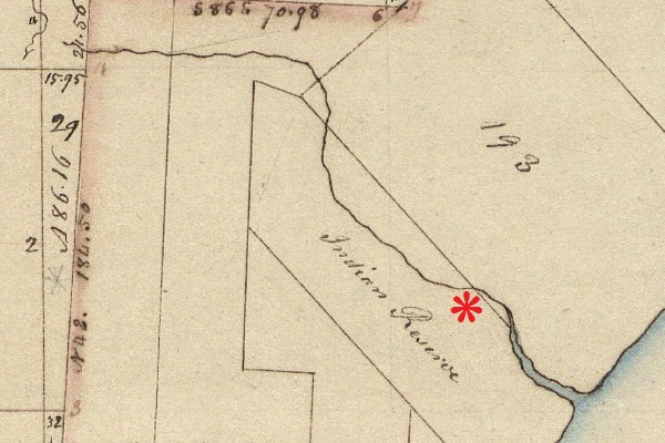
The site of the sandy knoll on an 1818 government survey of Chesterfield Township.
The Chippewa held the land as a reservation per the 1807 Treaty of Detroit.
It and other local reservations were ceded to the U.S. in 1836 when they
were traded for a thirteen square mile reservation west of the Mississippi River.

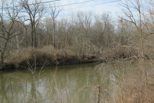
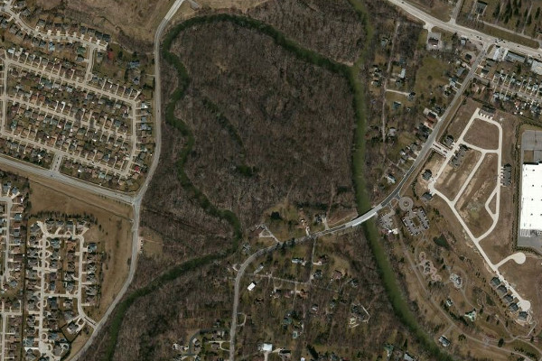
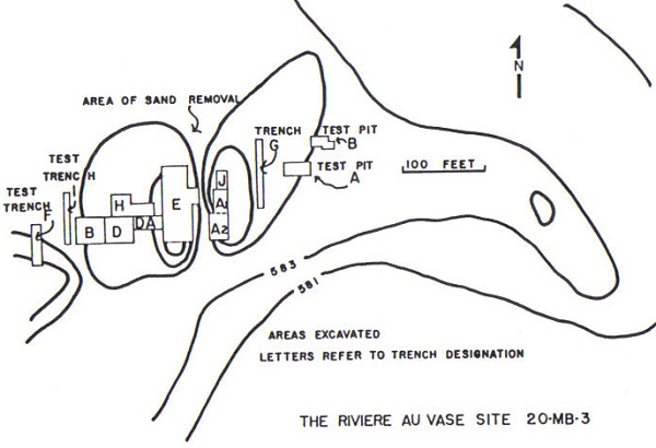
Whether the sand ridge behind the Green School was a natural formation or was partly human-made isn't known, but it had clearly once served as a significant Native American burial ground. Residents reported that part of the sandy knoll was removed for commercial purposes in 1927, upon which more skeletons were uncovered. This sand ridge, located on the south bank of the Riviere au Vase (now called Auvase Creek), was excavated in the summers of 1936 and 1937 by Professors Emerson Greenman and George Quimby of the University of Michigan. Remains from at least 350 individuals were removed. Samples taken from the site have been radiocarbon dated to between 900 and 1200 A.D.


From Late Woodland Cultures of Southeastern Michigan by James E. Fitting.
Image courtesy Alan Naldrett.

In his 1965 report on the 1936-1937 excavations, archaeologist James Fitting decries the poor quality of the record keeping associated with the digs and the subsequent site destruction. "After the University of Michigan excavations," he wrote, "the site was subject to much indiscriminant collecting. Many burials and features were destroyed and artifacts removed with no record of provenience. Only one other excavation was undertaken in a controlled manner and adequately reported. This was done by Mr. Jerry DeVisscher" in 1957.

One and a half miles to the northeast of this location, on the southwest bank of the Salt River, was a circular earthwork enclosure with an entrance facing the river. A white oak tree whose truck had a diameter of three feet grew in the middle of it as of 1837. I have not found any reference to this outside of Leeson's History of Macomb County and Robert F. Eldredge's Past and Present of Macomb County, Michigan.


Undisclosed Location, Southeast Michigan


We drove slowly along the dirt road, trying to spot something, anything through the forest. Even with the summer foliage gone, we couldn't make out any unusual mounds or hills.

But this was the right place. Hidden among the trees was, I believe, a circular earthwork--an "Indian fort"--similar to the one that used to lie in Springwells. The similarity between a 19th century eyewitness description and a shape faintly visible on a 20th century aerial photograph on that very spot couldn't be a coincidence.

Signs were posted nearly every ten feet around the property: "No Trespassing / No Hunting" -- "No Trespassing / Violators Will be Prosecuted" -- and a few weathered scraps of wood with hand-painted lettering: "NO TREZ." Maybe sneaking into the forest was a bad idea. We decided to park the car on the public road and walk up the long, muddy, pothole-filled driveway to speak directly to the property's residents. They will appreciate the direct, honest approach.

A dog chained to the front porch of the careworn house barked when we approached. I waved to a man I saw walking from the house to a pickup truck, but the Unsmiling Man did not wave back. He started his vehicle and drove towards us, and we waited for him rather than approach any farther. The silhouette of a second man appeared in the doorway.

The Unsmiling Man stopped his truck next to me with his window down. "Hi," I said, "I am a ... researcher of history." (Yes, that will do...) "I came across some historical records of an old Indian fort located on this land. The--"

"No." The Unsmiling Man was oddly unphased that someone had just walked up to his house talking about an Indian fort. Then, in a tone that was neither rude nor polite, yet unambiguously demarcated The End of the Conversation, he added, "Stay out of the woods."

The direct, honest approach did not work that day. All that was left to do was turn around and walk back down the long, swampy driveway, with the Unsmiling Man's truck following us all the day down to the road. We did not park near the driveway, but a short walk down the road. As we approached our car, a different pickup truck passed us from behind, turned around where our vehicle was parked, and then drove past us again. Was this the shadowy figure we had seen on the porch, protecting the non-existent Indian fort that isn't in the woods that we definitely shouldn't go into?

Although I was disappointed to have missed out on the chance to commune with the past amid the ruins of a lost civilization, let's face it--these events are essentially confirmation that prehistoric earthworks are very much intact right here in Metropolitan Detroit. And I am happy to see that they are hard to find, well hidden, and well protected.

Wait, should I just have bribed him instead?